GeoDjango + PostGIS + DRF
david.kwast@scicrop.com
Technology Specialist @ https://SciCrop.com
https://davidkwast.github.io/slides/geodjango-postgis-drf
Dependências
In [2]:
display.Code(filename='./Pipfile', language='toml')
Out[2]:
* Ubuntu 18.04
GDAL
a translator library for raster and vector geospatial data formats
Sistema Operacional
foo@bar:~$ apt install gdal-bin libgdal-dev

foo@bar:~$ gdalinfo --version
GDAL 2.2.3, released 2017/11/20
Pip(Env)
foo@bar:~$ pipenv install numpy

foo@bar:~$ export CPLUS_INCLUDE_PATH=/usr/include/gdal
foo@bar:~$ export C_INCLUDE_PATH=/usr/include/gdal
foo@bar:~$ pipenv install "gdal==2.2.3"
Python
from osgeo import gdal; gdal.UseExceptions() # type: ignore
from osgeo import ogr; ogr.UseExceptions() # type: ignore
PostgreSQL + PostGIS
Python
foo@bar:~$ pipenv install psycopg2-binary
SQL
CREATE EXTENSION POSTGIS;
- https://pypi.org/project/psycopg2-binary/
- The binary package is a practical choice for development and testing but in production it is advised to use the package built from sources.
- https://postgis.net/documentation/
foo@bar:~$ ls -l restgis/
total 16
drwxrwxr-x 3 kwast kwast 4096 mai 24 16:40 geoapi
-rw-rw-r-- 1 kwast kwast    0 mai 24 16:37 __init__.py
-rw-rw-r-- 1 kwast kwast 3091 mai 24 16:37 settings.py
-rw-rw-r-- 1 kwast kwast  749 mai 24 16:37 urls.py
-rw-rw-r-- 1 kwast kwast  391 mai 24 16:37 wsgi.py

foo@bar:~$ ls -l restgis/geoapi/
total 24
-rw-rw-r-- 1 kwast kwast   63 mai 24 16:40 admin.py
-rw-rw-r-- 1 kwast kwast   87 mai 24 16:40 apps.py
-rw-rw-r-- 1 kwast kwast    0 mai 24 16:40 __init__.py
drwxrwxr-x 2 kwast kwast 4096 mai 24 16:40 migrations
-rw-rw-r-- 1 kwast kwast   57 mai 24 16:40 models.py
-rw-rw-r-- 1 kwast kwast   60 mai 24 16:40 tests.py
-rw-rw-r-- 1 kwast kwast   63 mai 24 16:40 views.py
In [3]:
settings.INSTALLED_APPS
Out[3]:
foo@bar:~$ python manage.py runserver
Watching for file changes with StatReloader
Performing system checks...

System check identified no issues (0 silenced).

May 25, 2019 - 02:29:36
Django version 2.2.1, using settings 'restgis.settings'
Starting development server at http://127.0.0.1:8000/
Quit the server with CONTROL-C.
In [4]:
HOST = 'http://127.0.0.1:8000'
In [5]:
requests.get(f'{HOST}/api/test').json()
Out[5]:
In [6]:
display.Code(filename='./restgis/geoapi/api/test_api.py')
Out[6]:
In [7]:
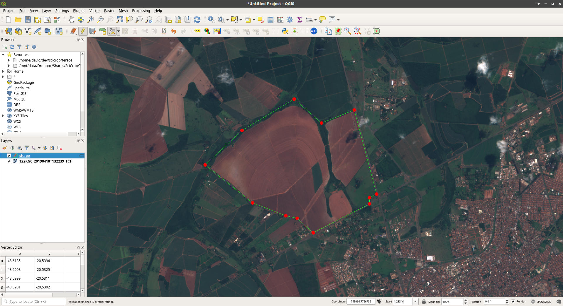
display.Image(url=f'{URL_SLIDES}/img/shape_01.jpeg')
Out[7]:
In [8]:
shape_raw = requests.get(f'{URL_SLIDES}/shapes/shape_01.geojson').text

shape_raw
Out[8]:
In [9]:
shape = json.loads(shape_raw)

shape
Out[9]:
In [10]:
shape_geometry = shape['features'][0]['geometry']

shape_geometry
Out[10]:
Obter o centróide de um polígono
In [11]:
requests.post(url=f'{HOST}/api/shape/centroid', json=shape_geometry).json()
Out[11]:
In [12]:
display.Code(filename='./restgis/geoapi/api/shape_centroid.py')
Out[12]:
In [13]:
display.Image(url=f'{URL_SLIDES}/img/satelite_01.jpeg')
Out[13]:
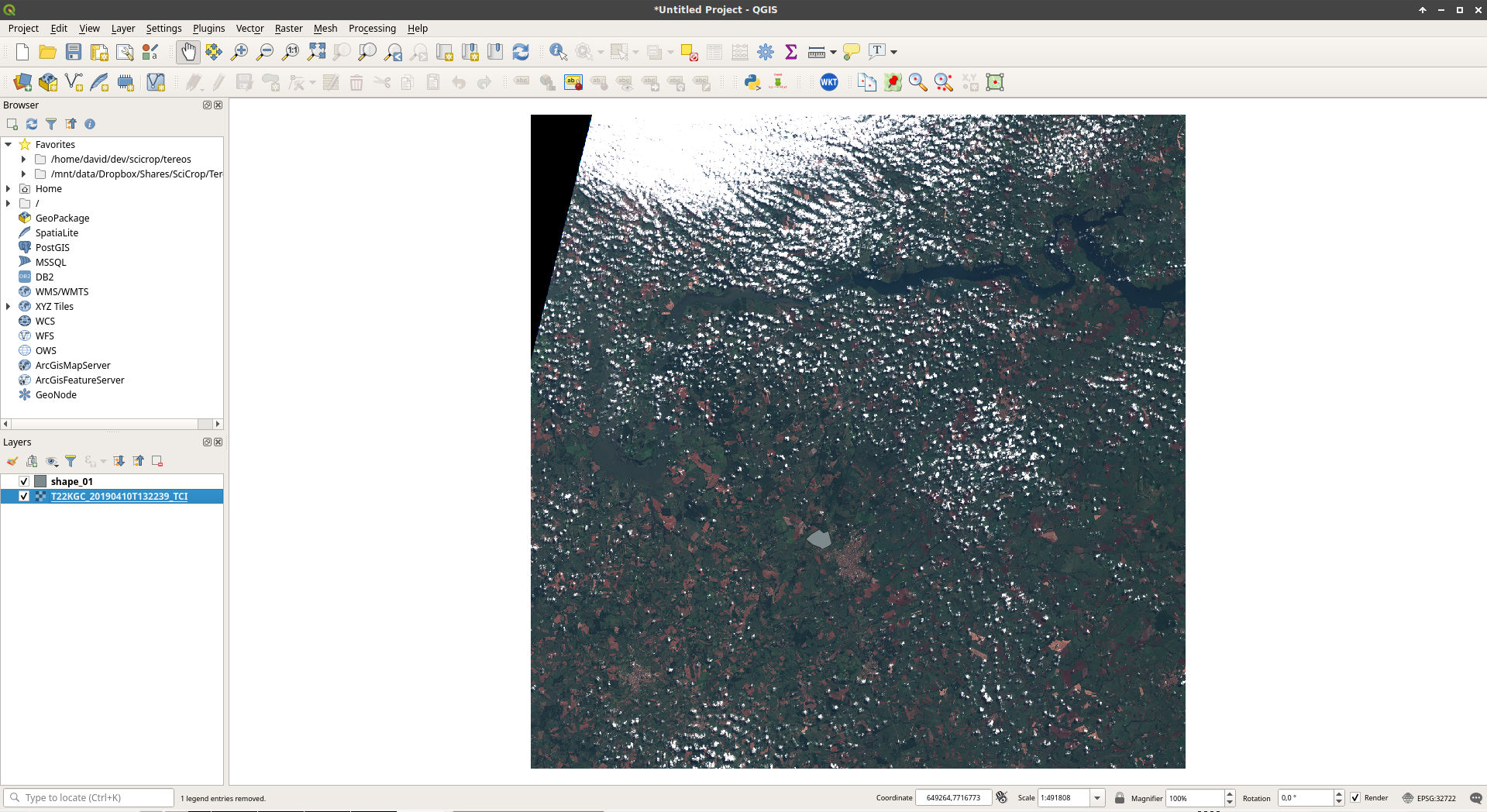
Cortar imagem de satélite
In [14]:
%%time
response = requests.post(
    url = f'{HOST}/api/shape/crop',
    json = shape_geometry,
    headers = {
        'Accept': 'image/png',
    }
)
In [15]:
response.headers['Content-Type']
Out[15]:
In [16]:
response.content[:100]
Out[16]:
In [17]:
len(response.content)
Out[17]:
In [18]:
display.Image(data=response.content)
Out[18]:

./restgis/geoapi/api/shape_crop.py
from rest_framework.decorators import api_view
from rest_framework.response import Response

from django.conf import settings
import tempfile
import json
from pathlib import Path
import numpy as np
import rasterio
import rasterio.mask
from rasterio.vrt import WarpedVRT

# urls.py: path('api/shape/crop', shape_crop.view)

@api_view(['POST'])
def view(request):
...
...
input_geojson = json.loads(request.body)

tci_rasterio = rasterio.open(settings.DEMO_IMAGE_SATELITE_FS_PATH)
tci_rasterio_dataset = WarpedVRT(tci_rasterio, crs='EPSG:4326')

tci_array, tci_affine = rasterio.mask.mask(
    tci_rasterio_dataset,
    [input_geojson],
    indexes = None,
    crop = True,
    all_touched = False,
    invert = False,
    nodata = 0, #np.nan,
    filled = True,
    pad = False,
)

tci_x_size, tci_y_size = tci_array.shape[2], tci_array.shape[1] # Z,Y,X
...
...
with tempfile.TemporaryDirectory() as tmpdirname:

    tci_image_path = Path(tmpdirname).joinpath('tci.png')

    with rasterio.open(
        tci_image_path, 'w', driver='PNG',
        dtype = 'uint8', count = 4,
        width = tci_x_size, height = tci_y_size,
        transform = tci_affine
    ) as tci_rast_fd:

        tci_rast_fd.write(tci_array[0], 1)
        tci_rast_fd.write(tci_array[1], 2)
        tci_rast_fd.write(tci_array[2], 3)
        tci_rast_fd.write(
            np.asarray(
                np.where(tci_array[0] > 0, 255, 0),
                dtype = np.uint8
            ),
            4
        )

    with open(tci_image_path ,'rb') as fd:
        payload = fd.read()

return Response(payload, content_type='image/png')
Models
In [19]:
display.Code(filename='./restgis/geoapi/models.py')
Out[19]:
foo@bar:~$ python manage.py makemigrations
Migrations for 'geoapi':
  restgis/geoapi/migrations/0001_initial.py
    - Create model Point
    - Create model Polygon

foo@bar:~$ python manage.py migrate
Operations to perform:
  Apply all migrations: auth, contenttypes, geoapi
Running migrations:
  Applying contenttypes.0001_initial... OK
  Applying contenttypes.0002_remove_content_type_name... OK
  Applying auth.0001_initial... OK
  Applying auth.0002_alter_permission_name_max_length... OK
  Applying auth.0003_alter_user_email_max_length... OK
  Applying auth.0004_alter_user_username_opts... OK
  Applying auth.0005_alter_user_last_login_null... OK
  Applying auth.0006_require_contenttypes_0002... OK
  Applying auth.0007_alter_validators_add_error_messages... OK
  Applying auth.0008_alter_user_username_max_length... OK
  Applying auth.0009_alter_user_last_name_max_length... OK
  Applying auth.0010_alter_group_name_max_length... OK
  Applying auth.0011_update_proxy_permissions... OK
  Applying geoapi.0001_initial... OK
--
-- Create model Point
--
CREATE TABLE "geoapi_point" (
    "id" serial NOT NULL PRIMARY KEY,
    "name" varchar(100) NOT NULL UNIQUE,
    "geometry" geometry(POINT,4326) NOT NULL
);
--
-- Create model Polygon
--
CREATE TABLE "geoapi_polygon" (
    "id" serial NOT NULL PRIMARY KEY,
    "name" varchar(100) NOT NULL UNIQUE,
    "geometry" geometry(POLYGON,4326) NOT NULL
);
--
--
CREATE INDEX "geoapi_point_name_c7d56075_like" ON "geoapi_point" ("name" varchar_pattern_ops);
CREATE INDEX "geoapi_point_geometry_id" ON "geoapi_point"USING GIST ("geometry");
CREATE INDEX "geoapi_polygon_name_d010f373_like" ON "geoapi_polygon" ("name" varchar_pattern_ops);
CREATE INDEX "geoapi_polygon_geometry_id" ON "geoapi_polygon"USING GIST ("geometry");
In [20]:
from restgis.geoapi import models
from django.contrib.gis import geos
In [21]:
models.Point.objects.all().delete()
Out[21]:
In [22]:
models.Polygon.objects.all().delete()
Out[22]:
In [23]:
centroid_dict = requests.post(url=f'{HOST}/api/shape/centroid', json=shape_geometry).json()
centroid_dict
Out[23]:
In [24]:
centroid_obj = models.Point.objects.create(
    name = 'centroid',
    geometry = geos.Point(centroid_dict['coordinates']),
)
centroid_obj
Out[24]:
In [25]:
centroid_obj.name, centroid_obj.geometry
Out[25]:
In [26]:
centroid_obj.geometry.x
Out[26]:
In [27]:
centroid_obj.geometry.y
Out[27]:
In [28]:
shape_geometry
Out[28]:
In [29]:
polygon_obj = models.Polygon.objects.create(
    name = 'shape',
    geometry = geos.Polygon(shape_geometry['coordinates'][0]),
)
polygon_obj
Out[29]:
In [30]:
polygon_obj.geometry
Out[30]:
In [31]:
polygon_obj.geometry.area
Out[31]:
In [32]:
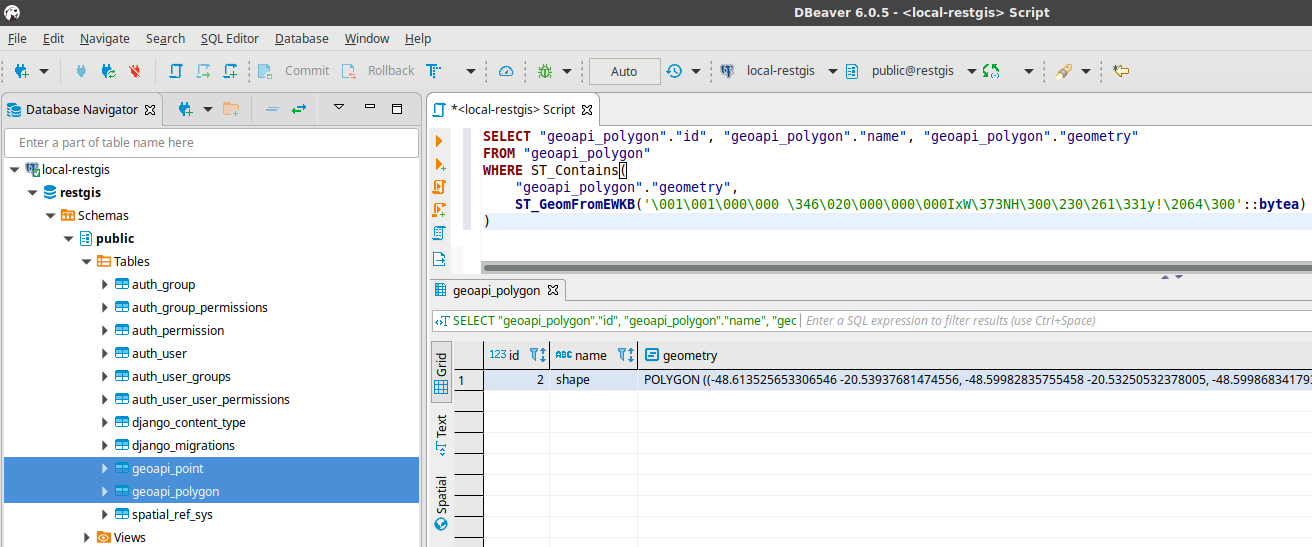
qs = models.Polygon.objects.filter(
    geometry__contains=centroid_obj.geometry
)
In [33]:
print(qs.query)
In [34]:
qs[0].name
Out[34]:
In [35]:
display.Image(url=f'{URL_SLIDES}/img/sql_01.png')
Out[35]: